 Mountain peaks
Top of Mount Saint Christoffel
Top of Mount Saint Christoffel
The Christoffelberg, also known as Mt Christoffel or Mt St Christoffel, named after Saint Christopher, is the highest point on Curaçao.
Wikipedia'da Oku
Aruba'daki en popüler turistik yerleri, simgeleri ve görülmesi gereken mekanları keşfedin.
41 ziyaret edilecek yer
Mountain peaksThe Christoffelberg, also known as Mt Christoffel or Mt St Christoffel, named after Saint Christopher, is the highest point on Curaçao.
Wikipedia'da Oku Geological formations
The Quadiriki Caves (other spellings include: Guadirikiri Caves, or Quadirikiri Cave) are located in Arikok National Park on the island of Aruba. There are three caves, which tourists commonly explore. The caves are located at the base of a limestone cliff. They contain Amerindian petroglyphs.
Wikipedia'da Oku Park
ParkThe Arikok National Park takes up approximately 18 percent of the island of Aruba and includes three primary geological formations: the Aruba lava formation, a quartz diorite formation, and a limestone formation that extends inward from the coast.
Wikipedia'da Oku Other
OtherThe Natural Pool, also known as "conchi" or "Cura di Tortuga", is a natural pool of water located in a very remote area in east Aruba. It is formed by rock and volcanic stone circles.
Wikipedia'da Oku Viewpoint
Mount Jamanota is at 188 meters (617 ft) the highest point on the island of Aruba and is visible from the entire island. It is located within the Arikok National Park. Wild goats, Aruba Rattlesnake and donkeys roam free on the mountain.
Wikipedia'da Oku Rock formations
The Aruba Natural Bridge was a tourist attraction in Arikok National Park, Aruba that was formed naturally out of coral limestone.
Wikipedia'da Oku Religious Site
Alto Vista Chapel is a small Catholic chapel also known as "Pilgrims Church" that stands on the hills above the north shore of the sea and to the northeast of the town of Noord, on the island of Aruba, 27 km north of the coast of Venezuela.
Wikipedia'da Oku Nature
Palm Beach is a tourism district about 6 kilometers northwest of Oranjestad, the capital of Aruba. A number of high rise hotels are located there, such as Hyatt Regency Aruba Resort & Casino, Aruba Marriott Resort, Occidental Grand Aruba, Holiday Inn SunSpree Resort, Ritz Carlton Resort, and RIU pal…
Wikipedia'da Oku Religious Site
St Ann's Church is a Roman Catholic Church located along the northern portion of Aruba island within the Catholic Diocese of Willemstad. Although rebuilt several times, the church traces its history back to 1776.
Wikipedia'da Oku Bridge
 Water
WaterLake Maracaibo (Spanish: Lago de Maracaibo, pronounced [ˈlaɣo ðe maɾaˈkajβo] (listen)) is a large brackish tidal bay (or tidal estuary) in Venezuela and an "inlet of the Caribbean Sea". It is sometimes considered a lake rather than a bay or lagoon.
Wikipedia'da Oku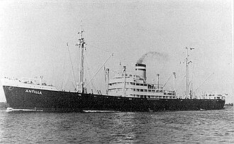 Dive spots
SS Antilla (or "ES Antilla", with "ES" standing for "Elektroschiff" German: electric ship) was a Hamburg America Line (HAPAG) cargo ship that was launched in 1939 and scuttled in 1940.Antilla was built for trade between Germany and the Caribbean, and was named accordingly.
Wikipedia'da Oku Nature
Eagle Beach (or Arend Beach) is a beach and neighbourhood of Oranjestad, Aruba. The neighbourhood is famous for its many low-rise resorts and wide public beach. It is the widest beach of Aruba, and has soft white sand. It has been rated one of the best beaches in the world.This is not a nude beach.
Wikipedia'da Oku Mountain peaks
Hooiberg is a 165 m (541 ft) high volcanic formation on the island of Aruba. It is located almost in the center of the island and can be seen from virtually anywhere on the island.The Dutch word hooiberg, literally translates into haystack in English, as the landform is said to resemble a stack of h…
Wikipedia'da Oku Religious Site
The St. Philomena's Church (Papiamento: Parokia Santa Filomena Dutch: St. Filomenakerk) is a religious building belonging to the Catholic Church located in the town of Paradera, on the Caribbean island of Aruba, an autonomous country in the Kingdom of the Netherlands in the Lesser Antilles.The templ…
Wikipedia'da Oku Aquatic protected areas
The Oranjestad Reef Islands lie just off the western coast of the island of Aruba, a constituent island nation of the Kingdom of the Netherlands in the Dutch Caribbean, adjacent to the central harbour of the capital Oranjestad.
Wikipedia'da Oku Religious Site
Beth Israel Synagogue is the synagogue of the Aruban Jewish community, located in Oranjestad, Aruba. Beth Israel Synagogue is an independent congregation with a liberal style similar to Reform Judaism or Conservative Judaism.
Wikipedia'da Oku Cultural
The Historical Museum of Aruba is a historical museum in the city of Oranjestad in Aruba. It explains the history of the island and its inhabitants, in rural and urban areas.The museum is situated in Fort Zoutman, an 18th and 19th-century military fortification.The museum is administrated by the Fun…
Wikipedia'da Oku National museums
Fort Zoutman (Dutch pronunciation: [fɔrt ˈsʌutmɑn]) is a military fortification at Oranjestad, Aruba. Originally built in 1798 by African slaves, with materials provided by the Amerindians, who performed Statute Labour or corvée for the Dutch West India Company, it is the oldest structure on th…
Wikipedia'da Oku Religious Site
The St. Francis of Assisi Church (Papiamento: Parokia San Francisco di Asis Dutch: Sint Franciscus Kerk) also alternatively called Pro Cathedral of St.
Wikipedia'da Oku Other
OtherThe Teta de Niquitao-Guirigay Natural Natural Monument (Spanish: Monumento Natural Teta de Niquitao-Guirigay) Is a protected natural space located in the Trujillo state, in the Andes of Venezuela. It has the highest mountain in the state with a height of 4006 meters.
Wikipedia'da Oku Historic architecture
The Sindoni Tower (also known as Filippo Sindoni Tower) is a building located in the Venezuelan city of Maracay. It is the highest in the city.
Wikipedia'da Oku Historic architecture
Jacinto Lara International Airport (IATA: BRM, ICAO: SVBM) is an airport in Barquisimeto, Venezuela, named after Venezuelan independence hero Jacinto Lara. It serves the city of Barquisimeto and others such as Acarigua, Yaritagua, and Carora, the main cities in the west-central area of Venezuela.
Wikipedia'da Oku Sport
SportDomo Bolivariano de Barquisimeto, or simply Domo Bolivariano, is an indoor sporting arena that is located in Barquisimeto, Venezuela. The arena is named in honor of Simón Bolívar.
Wikipedia'da Oku Cultural
El Teatro Baralt (English: The Baralt Theatre) is a theatre in downtown Maracaibo, Venezuela, at the northwestern corner of the historic Plaza Bolívar.
Wikipedia'da Oku Sport
SportPlaza de toros Monumental de Maracaibo is a bull ring in Maracaibo, Venezuela. It is currently used for bull fighting. The stadium holds 15,000 people and was built in 1972.
Wikipedia'da Oku Fortifications
San Carlos de la Barra Fortress is a seventeenth century star fort protecting Lake Maracaibo in Venezuela.
Wikipedia'da Oku Lighthouses
The California Lighthouse is a lighthouse located at Hudishibana near Arashi Beach on the northwest tip of Aruba.This lighthouse was named for the steamship California, which was wrecked nearby on September 23, 1891.The lighthouse has completed a recent restoration in May 2016 which coincided with t…
Wikipedia'da Oku National museums
The National Archaeological Museum Aruba (Papiamento: Museo Arqueologico Nacional Aruba) is an archaeological museum in the city of Oranjestad in Aruba. The collections covers from 2500 BCE to the 19th century.In 1981, the Archaeological Museum of Aruba was opened.
Wikipedia'da Oku Fortifications
La Guaira (Spanish: [la ˈɣwajɾa] (listen)) is the capital city of the Venezuelan state of the same name (formerly named Vargas) and the country's main port. It was founded in 1577 as an outlet for Caracas, 30 kilometres (19 mi) to the southeast.
Wikipedia'da Oku Other
OtherThe Astronomical and Meteorological Observatory of Caracas, was created by decree of President Juan Pablo Rojas Paul on September 8, 1888.
Wikipedia'da Oku Religious Site
The Cathedral Basilica of Our Lady of Coromoto (Spanish: Basílica Catedral Nuestra Señora de Coromoto) or more commonly Guanare Cathedral, is an eighteenth century church dedicated to the Virgin of Coromoto and located as its name indicates in Guanare, capital of Portuguesa state in Venezuela.
Wikipedia'da Oku Urban
UrbanThe Yacambú National Park (Spanish: Parque nacional Yacambú) is a protected area with national park status in the South American country of Venezuela.
Wikipedia'da Oku Fortifications
Fortín Solano is an eighteenth-century colonial fortification overlooking Puerto Cabello, Venezuela. With the Castillo San Felipe, an earlier fort built at sea level, it formed part of a complex of fortifications designed to protect Puerto Cabello and its important harbour from naval attacks.
Wikipedia'da Oku Urban
UrbanCerro Saroche National Park (Parque Nacional Cerro Saroche) is a Venezuelan national park located in the state of Lara, between Barquisimeto and Carora.
Wikipedia'da Oku Urban
UrbanMorrocoy National Park is located in the easternmost coast of Falcón state and northwestern of Golfo Triste, in the west central Venezuelan coast, near the towns of Boca de Aroa, Tucacas, Sanare, Chichiriviche, Flamenco and Tocuyo de la Costa, and consists of 12,990 hectares (32,090 acres).
Wikipedia'da Oku Religious Site
The Mikvé Israel-Emanuel Synagogue (Hebrew: בית הכנסת מקווה ישראל-עמנואל; English: The Hope of Israel-Emanuel Synagogue), in Willemstad, Curaçao, is the oldest surviving synagogue in the Americas.
Wikipedia'da Oku Mountain peaks
The Cerro Santa Ana Natural Monument (Spanish: Monumento Natural Cerro Santa Ana) Is a protected area with a natural monument status located in the center of the Paraguaná peninsula north of the Falcón state in the jurisdiction of the municipalities Falcón and Carirubana, between the populations…
Wikipedia'da Oku Nature
Baby Beach, is a shallow, sheltered lagoon located in the Mangel Cora locality near the village of Seroe Colorado (formerly Roode Berg), on the south-east end of the island of Aruba. It is frequented by locals and tourists.
Wikipedia'da OkuCarora Airport (IATA: VCR, ICAO: SVCO) is an airport serving the city of Carora in the Lara state of Venezuela.The Carora VOR-DME (Ident: COR) and non-directional beacon (Ident: COR) are located on the field.Transport in Venezuela List of airports in VenezuelaOpenStreetMaps - Carora OurAirports - Ca…
Wikipedia'da OkuThis is a list of lighthouses in Curaçao.Lists of lighthouses and lightvesselsRowlett, Russ. "The Lighthouse Directory". University of North Carolina at Chapel Hill.
Wikipedia'da OkuAruba, officially the Country of Aruba, is an island constituent country within the Kingdom of the Netherlands, in the southern Caribbean Sea 29 kilometres (18 mi) north of the Venezuelan peninsula of Paraguaná and 80 kilometres (50 mi) northwest of Curaçao. In 1986, Aruba became a constituent country within the Kingdom of the Netherlands and acquired the official name.
Wikipedia'da OkuUygun fiyatlı bir eSIM planı ile bağlı kalın — anında aktivasyon, roaming ücreti yok.
Aruba için eSIM planlarını görüntüleVeriler OpenTripMap & OpenStreetMap'ten