 Mountain peaks
Gunnuhver

Descubra as atrações, pontos turísticos e lugares imperdíveis mais populares de Islândia.
41 locais para visitar
Mountain peaks Water
WaterÖxarárfoss (Icelandic pronunciation: [ˈœksarˌaurˌfɔsː]) is a waterfall in Þingvellir National Park, Iceland. It flows from the river Öxará over the Almannagjá [ˈalˌmanːaˌcauː].
Ler na Wikipedia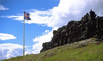 Other
OtherÞingvellir (Icelandic: [ˈθiŋkˌvɛtlɪr̥] (listen), anglicised as Thingvellir) was the site of the Alþing, the annual parliament of Iceland from the year 930 until the last session held at Þingvellir in 1798. Since 1881, the parliament has been located within Alþingishúsið in Reykjavík.
Ler na Wikipedia Rock formations
Lögberg (Icelandic pronunciation: [ˈlœɣˌpɛrk]), or Law Rock, was a rocky outcrop in south west Iceland, at the location for the assembly of the country's Althing parliament.
Ler na Wikipedia Mountain peaks
Brennisteinsfjöll (Icelandic pronunciation: [ˈprɛnːɪˌsteinsˌfjœtl̥], "Sulfur mountains") is a minor volcanic system, with crater rows and small shield volcanoes on the Reykjanes Peninsula in southwest Iceland.The mountain range is located at about 20 to 25 km (12 to 16 mi) from Reykjavík a…
Ler na Wikipedia Mountain peaks
Keilir (Icelandic pronunciation: [ˈcʰeiːlɪr̥]; 378 m asl) is a Pleistocene subglacial mound or perhaps a conical tuya on Reykjanes Peninsula in Iceland.
Ler na Wikipedia Mountain peaks
Grensdalur (Icelandic pronunciation: [ˈkrɛnsˌtaːlʏr̥]) is a volcano in Iceland. The elevation is about 497 m (1631 ft). Its position is 64.02°N 21.17°W. It was active during Pleistocene."Grensdalur". Global Volcanism Program. Smithsonian Institution. Retrieved 2021-06-25.
Ler na Wikipedia Hot springs
The Blue Lagoon (Icelandic: Bláa lónið [ˈplauːa ˈlouːnɪθ]) is a geothermal spa in southwestern Iceland. The spa is located in a lava field near Grindavík and in front of Mount Þorbjörn on Reykjanes Peninsula, in a location favourable for geothermal power, and is supplied by water used in…
Ler na Wikipedia Religious Site
Strandarkirkja (Icelandic pronunciation: [ˈstrantarˌcʰɪr̥ca]) is a Lutheran (Church of Iceland) parish church in Selvogur, on the southern coast of Iceland. The church is a landmark for travellers at sea.
Ler na Wikipedia Mountain peaks
Hrómundartindur (Icelandic pronunciation: [ˈr̥ouːˌmʏntarˌtʰɪntʏr̥]) is a volcano in Iceland. It is a stratovolcano with an elevation of 540 metres (1,770 ft).Hrómundartindur in the Catalogue of Icelandic Volcanoes
Ler na Wikipedia Mountain peaks
The volcanic system of Krýsuvík (or Krísuvík, both pronounced [ˈkʰriːsʏˌviːk] in Icelandic), also Krýsuvík-Trölladyngja [ˈtʰrœtlaˌtiɲca] volcanic system, is situated in the southwest of Iceland on the Reykjanes peninsula.
Ler na Wikipedia Mountain peaks
Sveifluháls (Icelandic pronunciation: [ˈsveiplʏˌhauls]) is a mafic hyaloclastite ridge of 397 m height in the southwest of Iceland in Gullbringusýsla (Reykjanes Peninsula).
Ler na Wikipedia Mountain peaks
Vífilsfell (Icelandic pronunciation: [ˈviːvɪlsˌfɛtl̥]) is a hyaloclastite ridge in southwestern Iceland (Weichselian). It is 655 m high and located west of Jósepsdalur valley on the volcanic plateau of Hellisheiði.
Ler na Wikipedia Museum
The Akranes Folk Museum (Icelandic: Byggðasafnið í Görðum Akranesi [ˈpɪɣðaˌsapnɪð i ˈkœrðʏm ˈaːkraˌnɛːsɪ]), formerly known as the Akranes Museum Centre (Safnasvæðið á Akranesi [ˈsapnaˌsvaiːðɪð au ˈaːkraˌnɛːsɪ]), consists of a folk museum, an exhibition hall and…
Ler na Wikipedia Mountain peaks
Þverfellshorn (Icelandic pronunciation: [ˈθvɛrˌfɛlsˌhɔ(r)tn̥]) is a peak in the Esjan mountains of Capital Region (Greater Reykjavík) in southwestern Iceland. It is located roughly 15 kilometres (9.3 mi) by air northeast of Reykjavík.
Ler na Wikipedia Mountain peaks
Búrfell (Icelandic pronunciation: [ˈpurˌfɛtl̥]) and the connected lava channel Búrfellsgjá [ˈpurˌfɛlsˌcauː] are famous landmarks of the Reykjanes peninsula, Southwest Iceland. They are part of the Krýsuvík volcanic system.The name Búrfell is widespread in Iceland.
Ler na Wikipedia Historic
The Imagine Peace Tower (Icelandic: Friðarsúlan [ˈfrɪːðarˌsuːlan], "the peace column") is a memorial to John Lennon from his widow, Yoko Ono, located on Viðey Island in Kollafjörður Bay near Reykjavík, Iceland.
Ler na Wikipedia Religious Site
Kópavogskirkja (Icelandic pronunciation: [ˈkʰouːpaˌvɔksˌcʰɪr̥ca]) is a church in Kópavogur, Iceland. It is located on Borgarholt hill at the top of Kársnes and offers a great view over Kópavogur, Reykjavík and surrounding area.Work on it began in 1958 and it was opened on December 16…
Ler na Wikipedia Religious Site
The Reykjavík Mosque (Icelandic: Moskan í Reykjavík) is a mosque and gathering area for Muslims in Iceland. It is located in the Ármúli district.
Ler na Wikipedia Urban
UrbanReykjavík Botanic Garden (Latin: Hortus Botanicus Reykjavikensis, Icelandic: Grasagarður Reykjavíkur [ˈkraːsaˌkarðʏr ˈreiːcaˌviːkʏr̥]) is a botanical garden located in the district of Laugardalur in Reykjavík that was established on August 18, 1961 on the 175th anniversary of the city…
Ler na Wikipedia Religious Site
Hallgrímskirkja (Icelandic pronunciation: [ˈhatl̥ˌkrimsˌcʰɪr̥ca], church of Hallgrímur) is a Lutheran (Church of Iceland) parish church in Reykjavík, Iceland. At 74.5 metres (244 ft) tall, it is the largest church in Iceland and among the tallest structures in the country.
Ler na Wikipedia Historic
Leif Erikson, Leiv Eiriksson or Leif Ericson also known as Leif the Lucky (Old Norse Leifr hinn Heppni) (c. 970 – c. 1020) was a Norse explorer from Iceland.
Ler na Wikipedia Nature
The Vatnsmýrin Nature Reserve (Icelandic pronunciation: [ˈvassˌmiːrɪn], "water marsh") is a protected moorland in Reykjavík, Iceland. The reserve provides a water source for Tjörnin Lake and is a nesting ground for birds. It borders the Nordic House and the University of Iceland.
Ler na Wikipedia Cultural
The National Theatre of Iceland (Icelandic: Þjóðleikhúsið, pronounced [ˈθjouðˌleikˌhuːsɪθ]) in Reykjavík, is the national theatre of Iceland. The theater, designed by Guðjón Samúelsson, was formally opened on April 20, 1950.
Ler na Wikipedia Cultural
Safnahúsið (Icelandic pronunciation: [ˈsapnaˌhuːsɪθ], "the Culture House"), formerly Þjóðmenningarhúsið [ˈθjouðˌmɛnːiŋkarˌhuːsɪθ], is an exhibition space in Reykjavík, Iceland, which houses an exhibition, Points of View, drawn from various national museums and other cultural…
Ler na Wikipedia National museums
The National Museum of Iceland (Þjóðminjasafn Íslands [ˈθjouðˌmɪnjaˌsapn ˈistlan(t)s]) was established on 24 February 1863, with Jón Árnason the first curator of the Icelandic collection, previously kept in Danish museums.
Ler na Wikipedia National museums
The National Gallery of Iceland (Icelandic: Listasafn Íslands [ˈlɪstaˌsapn ˈistlan(t)s]) is an art museum in Reykjavík which contains a collection of Icelandic art.
Ler na Wikipedia Entertainment
Harpa (Icelandic pronunciation: [ˈhar̥pa]) is a concert hall and conference centre in Reykjavík, Iceland. The opening concert was held on May 4, 2011. The building features a distinctive colored glass facade inspired by the basalt landscape of Iceland.
Ler na Wikipedia Religious Site
The Fríkirkjan í Reykjavík (Icelandic: The Free Church in Reykjavik) is a church which is apart from the State Church. It is an independent Lutheran Free Church of Iceland. It lies in the centre of the Icelandic capital, by the lake Tjörnin.
Ler na Wikipedia Cultural
The Icelandic Phallological Museum (Icelandic: Hið íslenska reðasafn [ˈhɪːð ˈistlɛnska ˈrɛːðaˌsapn̥]), located in Reykjavík, Iceland, houses the world's largest display of penises and penile parts.
Ler na Wikipedia Wall painting
Reykjavik Art Museum (Icelandic: Listasafn Reykjavíkur [ˈlɪstaˌsapn ˌreiːcaˌviːkʏr̥]; founded in 1973) is the largest visual art institution in Iceland.
Ler na Wikipedia Cultural
ICGV Óðinn is a decommissioned offshore patrol vessel formerly operated by the Icelandic Coast Guard. She is the oldest ship in the coastguard's fleet, and it is believed that her Burmeister & Wain engines are the only such engines that are still serviceable in the world today.
Ler na Wikipedia Cultural
The Reykjavik Maritime Museum (Icelandic: Sjóminjasafnið í Reykjavík [ˈsjouːˌmɪnjaˌsapnɪð i ˈreiːcaˌviːk]), formerly Víkin Maritime Museum, is a maritime museum located by the old harbour in the capital of Iceland, Reykjavík and run by Reykjavik City.
Ler na Wikipedia Religious Site
Landakotskirkja (Landakot's Church), formally Basilika Krists konungs (The Basilica of Christ the King), is the cathedral of the Catholic Church in Iceland.
Ler na Wikipedia Nature
Surtsey ("Surtr's island" in Icelandic, Icelandic pronunciation: [ˈsʏr̥(t)sˌeiː]) is a volcanic island located in the Vestmannaeyjar archipelago off the southern coast of Iceland. At 63.303°N 20.605°W / 63.303; -20.605, Surtsey is the southernmost point of Iceland.
Ler na Wikipedia Landmark
Þjórsá (Icelandic pronunciation: [ˈθjour̥sˌauː]) is Iceland's longest river at 230 kilometers (about 143 miles). It is in the south of the island.Þjórsá is a glacier river and has its source on the glacier Hofsjökull. It flows out through narrow gorges in the highlands of Iceland.
Ler na Wikipedia Water
WaterGljúfrafoss (Icelandic pronunciation: [ˈkljuvraˌfɔsː]) or Gljúfrabúi [-ˈpuːɪ] ("one who lives in the canyon") is a small waterfall north of the larger falls of Seljalandsfoss in Iceland.
Ler na Wikipedia Mountain peaks
Ok (Icelandic pronunciation: [ˈɔːk]; 1198 m) is a shield volcano in Iceland, to the west of Langjökull. It erupted during interglacials in the Pleistocene. The volcano was once topped by the Okjökull glacier, which is now thought to have disappeared.
Ler na Wikipedia Mountain peaks
Þorbjörn (Icelandic pronunciation: [ˈθɔrˌpjœ(r)tn̥]) is a volcanic mountain of 243 m next to the town of Grindavík (Gullbringusýsla) on Reykjanes peninsula, Iceland. Blue Lagoon can be easily seen from the summit.
Ler na Wikipedia Cultural
Egilshöll (Icelandic pronunciation: [ˈeijɪlsˌhœtl̥]) is a multi-purpose sports facility in Reykjavík, Iceland. It features three football pitches, an ice rink, an arena, shooting range and tennis courts.
Ler na Wikipedia Cultural
Árbæjarsafn (Icelandic pronunciation: [ˈauːrˌpaiːjar̥ˌsapn̥]) is the historical museum of the city of Reykjavík as well as an open-air museum and a regional museum.
Ler na WikipediaIceland is a Nordic island country between the Arctic Ocean and the North Atlantic Ocean, located on the Mid-Atlantic Ridge between Europe and North America. It is culturally and politically linked with Europe and is the region's westernmost and most sparsely populated country. Its capital and largest city is Reykjavík, which is home to about 35% of the country's roughly 395,000 residents. The official language of the country is Icelandic.
Ler na WikipediaFique conectado com um plano eSIM acessível — ativação instantânea, sem taxas de roaming.
Ver planos eSIM para IslândiaDados do OpenTripMap & OpenStreetMap