 Religious Site
Roman Catholic Diocese of Jalapa
Roman Catholic Diocese of Jalapa
The Diocese of Jalapa is a Latin Church ecclesiastical territory or diocese of the Catholic Church in southeastern Guatemala.
Leggi su Wikipedia
Scopri le attrazioni più popolari, i monumenti e i luoghi da visitare in Guatemala.
48 luoghi da visitare
Religious SiteThe Diocese of Jalapa is a Latin Church ecclesiastical territory or diocese of the Catholic Church in southeastern Guatemala.
Leggi su Wikipedia Religious Site
La Merced Church is a baroque church in Antigua Guatemala.The Mercedarians were the first to establish a male monastery at the former Santiago de Guatemala.
Leggi su Wikipedia Religious Site
 Religious Site
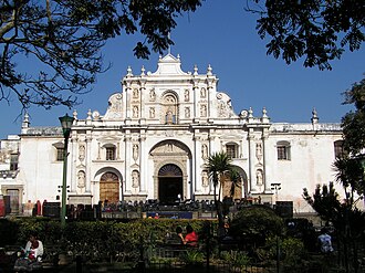
Antigua Guatemala Cathedral (Spanish: Catedral de San José) is a Latin Catholic church in Antigua Guatemala, Guatemala. The original church was built around 1541, but suffered several earthquakes throughout its history, and the first church building was demolished in 1669.
Leggi su Wikipedia Religious Site
The Guatemala City Guatemala Temple (formerly the Guatemala City Temple) is the 34th constructed and 32nd operating temple of The Church of Jesus Christ of Latter-day Saints (LDS Church).
Leggi su Wikipedia Skyscrapers
The Tikal Futura, formally Gran Tikal Futura Torres Sol y Luna is a modern shopping and business complex and hotel in Guatemala City, Guatemala.It is located at Calzada Roosevelt 22-43, in Zone 11 of the city. At 75 metres, as of 2009 it is the fourth tallest building in Guatemala City.
Leggi su Wikipedia Cultural
The Centro Cultural Miguel Ángel Asturias, commonly called Teatro Nacional, is a cultural center in Guatemala City, Guatemala. It is located in the Centro Cívico (Civic Center) of the city and was built in the same place of the old Fuerte de San José.
Leggi su Wikipedia Geological formations
Naj Tunich (Mopan Maya: /nah tunit͡ʃ/ "stone house, cave") is a series of pre-Columbian era natural caves outside the village of La Compuerta, roughly 35 km east of Poptún in Guatemala. The site was a Maya ritual pilgrimage site during the Classic period.
Leggi su Wikipedia Park
ParkNaciones Unidas National Park is a forested park area of 4.91 km2, located 21 km south of Guatemala City, just north of Lake Amatitlán in the municipality of Villa Nueva. It is one of the last remaining nature reserves in the Guatemala City Metropolitan Area.
Leggi su Wikipedia Skyscrapers
Premiere Club is a skyscraper in Guatemala City, Guatemala located at 4a. Avenida Final x Calle 23, in Zone14. As of 2020, it is the tallest building in Guatemala at 100.75 m (330.5 ft). The building has 31 floors and was completed in 1999.
Leggi su Wikipedia Historic
The Carrera Theater -also called Colón Theater after the Liberal Reform of 1871– was a majestic classic Greek style theater built by president Captain General Rafael Carrera y Turcios in Guatemala City, Guatemala in 1852.
Leggi su Wikipedia Religious Site
The Holy Church Cathedral Metropolitan Basilica of Santiago de Guatemala also Metropolitan Cathedral, officially Catedral Primada Metropolitana de Santiago, is the main church of Guatemala City and of the Archdiocese of Guatemala (Archidioecesis Guatimalensis).
Leggi su Wikipedia Cultural
Guatemala is one of the 22 departments of Guatemala. The capital is Guatemala City, which also serves as the national capital.
Leggi su Wikipedia Religious Site
The Temple of Minerva was a Greek style temple erected in Guatemala City by the government of president Manuel Estrada Cabrera in 1901 to celebrate the Fiestas Minervalias.
Leggi su Wikipedia Architecture
The Torre del Reformador (Tower of the Reformer) is a 71.85 meter (236 ft.) tall steel framework tower in Zone 9 of Guatemala City.
Leggi su Wikipedia Park
ParkLagunas de Montebello, or Montebello Lakes, (Spanish: Parque Nacional Lagunas de Montebello) is a national park in the Mexican state of Chiapas, near the border with Guatemala, comprising 59 multi-colored lakes in a pine forest and two Maya ruins.
Leggi su Wikipedia Historic
Chichicastenango, also known as Santo Tomás Chichicastenango, is a town, with a population of 71,394 (2018 census), and the municipal seat for the surrounding municipality of the same name in the El Quiché department of Guatemala.
Leggi su Wikipedia Crater lakes
Lake Atitlán (Spanish: Lago de Atitlán, [atiˈtlan]) is a lake in the Guatemalan Highlands of the Sierra Madre mountain range. It is in the Sololá Department of southwestern Guatemala. It is the deepest lake in Central America.Atitlán means "between the waters".
Leggi su Wikipedia Historic
Ciudad Vieja (Spanish pronunciation: [sjuˈðað ˈβjexa]) is a town and municipality in the Guatemalan department of Sacatepéquez. According to the 2018 census, the town has a population of 32,802 and the municipality a population of 33,405.
Leggi su Wikipedia Historic
Antigua Guatemala (Spanish pronunciation: [anˈtiɣwa ɣwateˈmala]), commonly referred to as just Antigua or la Antigua, is a city in the central highlands of Guatemala known for its preserved Spanish Baroque-influenced architecture as well as a number of ruins of colonial churches.
Leggi su Wikipedia Palaces
Known as Palacio Nacional de la Cultura (National Palace of Culture) also known colloquially as "Palacio Verde", it is identified as Guatemala City's symbol in its architectural context. It was the most important building in Guatemala and was the headquarters of the President of Guatemala.
Leggi su Wikipedia Palaces
The Captain General Palace, or Palacio de los Capitanes Generales, is a large building localed in the Central Square of Antigua Guatemala. It serves as the headquarters of the Guatemala Institute of Tourism, the Antigua Tourism Association, National Police and the Sacatepquez Department government.
Leggi su Wikipedia Cultural
The Museo Miraflores is an archaeological museum in Guatemala City, dedicated to the display of artefacts from the ancient Maya city of Kaminaljuyu. The museum is open from Tuesday through to Sunday.The museum was founded in 2002.
Leggi su Wikipedia Other
OtherThe Relief Map of Guatemala (in Spanish: Mapa en Relieve de Guatemala) is a huge relief map of Guatemala erected at ground level on two scales: 1: 10,000 for the horizontal extension and 1: 2,000 for the vertical, on an approximate surface of 1,800 square meters.
Leggi su Wikipedia Historic
Tayasal is a Maya archaeological site located in present-day Guatemala. It was a large Maya city with a long history of occupation. Tayasal is a corruption of Tah Itza ("Place of the Itza"), a term originally used to refer to the core of the Itza territory in Petén.
Leggi su Wikipedia Historic
Nojpetén (also spelled Noh Petén, and also known as Tayasal) was the capital city of the Itza Maya kingdom of Petén Itzá, located on an island in Lake Petén Itzá in the modern department of Petén in northern Guatemala.
Leggi su Wikipedia Urban
UrbanCusuco National Park is a national park in Honduras. It was established on 1 January 1959 and covers an area of 234.4 square kilometres (90.5 sq mi).Cusuco National Park is a 23,400 hectares (58,000 acres) protected area in the Merendon mountains of northwest Honduras.
Leggi su Wikipedia Cultural
Museum of the Revolution (Spanish: Museo de la Revolución) is a museum commemorating the antecedents and events of the Salvadoran Civil War, which took place from approximately 1980 until 1992. The museum is located in Perquín, in the Morazán Department of El Salvador.
Leggi su Wikipedia Mountain peaks
The volcano Tacaná is the second highest peak in Central America at 4,060 metres (13,320 ft), located in the Sierra Madre de Chiapas of northern Guatemala and southern Mexico.
Leggi su Wikipedia Historic
Tazumal (/täsuːˈm äl/) is a pre-Columbian Maya archeological site in Chalchuapa, El Salvador. Tazumal is an architectural complex within the larger area of the ancient Mesoamerican city of Chalchuapa, in western El Salvador.
Leggi su Wikipedia Mountain peaks
Moyuta is a stratovolcano in southern Guatemala. It is located near the town of Moyuta in Santa Rosa Department, and is situated at the southern edge of the Jaltapagua fault. The volcano has an elevation of 1662 m and its summit is formed by three andesitic lava domes.
Leggi su Wikipedia Mountain peaks
Cerro Santiago is one of the most prominent cinder cones of a volcanic field surrounding the city of Jutiapa in southern Guatemala.List of volcanoes in Guatemala"Cerro Santiago". Global Volcanism Program. Smithsonian Institution.
Leggi su Wikipedia Religious Site
Pascual Abaj (alternatively written Pascual Ab'aj), also known as Turcaj, Turk'aj, Turuk'aj and Turukaj, is a pre-Columbian Maya idol at Chichicastenango that survived the Spanish conquest of Guatemala and which is still venerated by the local community.
Leggi su Wikipedia Mountain peaks
Volcán Atitlán (Spanish pronunciation: [atiˈtlan]) is a large, conical, active stratovolcano adjacent to the caldera of Lake Atitlán in the Guatemalan Highlands of the Sierra Madre de Chiapas range.
Leggi su Wikipedia Mountain peaks
Tolimán is a stratovolcano in Guatemala, on the southern shores of Lake Atitlán. The volcano has an elevation of 3,158 m (10,361 ft) and was formed near the southern margin of the Pleistocene Atitlán III caldera.
Leggi su Wikipedia Mountain peaks
Tahual is a stratovolcano in southern Guatemala.List of volcanoes in Guatemala"Tahual". Global Volcanism Program. Smithsonian Institution.
Leggi su Wikipedia Mountain peaks
Volcán de Agua (also known as Hunahpú by Maya) is a stratovolcano located in the departments of Sacatepéquez and Escuintla in Guatemala.
Leggi su Wikipedia Mountain peaks
Pacaya is an active complex volcano in Guatemala, which first erupted approximately 23,000 years ago and has erupted at least 23 times since the Spanish conquest of Guatemala. It rises to an elevation of 2,552 metres (8,373 ft).
Leggi su Wikipedia Architecture
La Recolección Architectural Complex is a former church and monastery of the Order of the Recollects (Ordo Fratrum Minorum Recollectorum) and its adjacent park in Antigua, Guatemala. It is in the western part of the old city.
Leggi su Wikipedia Religious Site
The Church and convent of the Society of Jesus in Antigua Guatemala is a religious complex that was built between 1690 and 1698.
Leggi su Wikipedia Cultural
The Guatemala City Railway Museum, officially Museo del Ferrocarril FEGUA, is located in the main railway station in Guatemala City, Guatemala.The museum has a collection of steam and diesel locomotives, passenger carriages and other rolling stock and items connected with the railway.
Leggi su Wikipedia Cemeteries
The Guatemala City General Cemetery was built in 1880, during general Justo Rufino Barrios presidency. Ruined by 1917-18 earthquakes, it never recovered its old splendor; originally it was exclusive for the elites and presidents, but gradually the eight Mayan hills that form it were invaded without…
Leggi su Wikipedia Architecture
The Santa Catalina Arch is one of the distinguishable landmarks in Antigua Guatemala, Guatemala, located on 5th Avenue North.
Leggi su WikipediaLa Encrucijada Biosphere Reserve (Spanish: Reserva de la Biósfera La Encrucijada) (established 2006) is a UNESCO Biosphere Reserve situated in the Pacific Coastal Lowlands physiographic region of Mexico.
Leggi su WikipediaMontecristo Trifinio National Park is a national park in Honduras. It was established on 1 January 1987 and covers an area of 54 square kilometres.The Montecristo massif is an area where the borders of Honduras, Guatemala and El Salvador meet, and its protection was a joint initiative of these three…
Leggi su WikipediaThe Roman Catholic Diocese of Huehuetenango, Guatemala was first erected 22 July 1961, as the Territorial Prelature of Huehuetenango. It is a suffragan diocese of the Archdiocese of Los Altos Quetzaltenango-Totonicapán. It was elevated as a diocese on 23 December 1967.Hugo Mark Gerbermann, M.M.
Leggi su WikipediaEl Obelisco or Monumento a los Próceres de la Independencia is a monument in Guatemala City, Guatemala built in 1935 under dictator Jorge Ubico and designed by Rafael Pérez De León. It commemorates the independence of Central America.
Leggi su WikipediaThe Parque Zoológico La Aurora is a zoological park in Guatemala City, Guatemala. It is one of the largest gardens within the city. The zoo has three different areas, where animals from Asia, The Americas and Africa can be appreciated.
Leggi su WikipediaGuatemala, officially the Republic of Guatemala, is a country in northern Central America. It is bordered to the north and west by Mexico, to the northeast by Belize, to the east by Honduras, and to the southeast by El Salvador. It is bounded by the Pacific Ocean to the south and the Gulf of Honduras to the northeast.
Leggi su WikipediaResta connesso con un piano eSIM conveniente — attivazione istantanea, senza costi di roaming.
Vedi piani eSIM per GuatemalaDati da OpenTripMap & OpenStreetMap