 Mountain peaks
Loenpo Gang

Entdecken Sie die beliebtesten Attraktionen, Wahrzeichen und Sehenswürdigkeiten in Nepal.
63 Orte zu besuchen
Mountain peaks Religious Site
The Thrangu Tashi Yangtse Monastery is a Tibetan Buddhist monastery about 40 km (by road) southeast of Nepal's capital city Kathmandu and 2.3km from Manegaun, a Tamang village. It lies at the top of the hill in Namobuddha Municipality. It is one of the most beautiful and a center for tourism.
Auf Wikipedia lesen Religious Site
Chandeshwari is the avatar taken by Hindu goddess Kumari of Hindu. The 'Nepal Mahatmya' of Skanda Purana mentions the story related to goddess Chandeshwari.Along Arniko Highway 5 kilometers before Dhulikhel is the town of Banepa, Nepal.
Auf Wikipedia lesen Religious Site
Dakshin kali Temple, also Dakshina Kali Temple, located 22 kilometres (14 mi) outside Kathmandu and about 1 kilometre (0.6 mi) outside the village of Pharping, is one of the major Hindu temples in Nepal dedicated to the goddess Kali.
Auf Wikipedia lesen Viewpoint
Kopan Monastery is a Tibetan Buddhist monastery near Boudhanath, on the outskirts of Kathmandu, Nepal. It is a member of the Foundation for the Preservation of the Mahayana Tradition (FPMT), an international network of Gelugpa dharma centers, and once served as its headquarters.The monastery was est…
Auf Wikipedia lesen Religious Site
Taleju Temple is a Hindu temple dedicated to Taleju Bhawani, the royal goddess of the Malla dynasty of Nepal. It was built in 1564 by Mahendra Malla and is located in Hanuman Dhoka, Kathmandu Durbar Square, a UNESCO Heritage site.
Auf Wikipedia lesen Urban
UrbanRatna Park is a park and surrounding district in central Kathmandu, Nepal. It is named after Queen Ratna, the wife of King Mahendra. It was built for the children and is named after Ratna, the second queen of King Mahendra. It is situated between Rani Pokhari and Tudikhel in the heart of Kathmandu.
Auf Wikipedia lesen Religious Site
Nyatapola Temple (Nepal Bhasa: 𑐒𑐵𑐟𑐵𑐥𑑀𑐮𑑃/ 𑐒𑐵𑐟𑐵𑐥𑑀𑐮𑑂𑐴𑑃 ,Devanagari Alphabet:ङातापोलँ where: Nyata "ङाता"= 5 Storeys " पाँच तल्ला & Pola "पोलँ" = Roof "छाना")is a five-stories Pagoda tem…
Auf Wikipedia lesen Religious Site
The Sheshnarayan Temple is an ancient Hindu temple complex in Sheshnarayan Village Development Committee (VDC). The site is near the ancient town of Pharping, which lies approximately 20 kilometers south-west of Kathmandu, Nepal.The temple is one of the four Narayana temples of the Kathmandu Valley…
Auf Wikipedia lesen Park
ParkShivapuri Nagarjun National Park is the ninth national park in Nepal and was established in 2002. It is located in the country's mid-hills on the northern fringe of the Kathmandu Valley and named after Shivapuri Peak of 2,732 m (8,963 ft) altitude.
Auf Wikipedia lesen Religious Site
Karya Binayak (कार्यविनायक मन्दिर) is a Hindu temple located in Bungamati, Lalitpur District at about 10 kilometres south of Kathmandu.Information related to Karya Binayak Temple. Information about Karya Binayak Temple.
Auf Wikipedia lesen Religious Site
Budhanilkantha Temple, located in Budhanilkantha, Nepal, (Nepali: बुढानिलकण्ठ मन्दिर; translation: Old Blue Throat) is a Hindu open air temple dedicated to Lord Mahavishnu.
Auf Wikipedia lesen Religious Site
Hiraṇyavarṇa Mahāvihāra (Nepali: हिरण्यवर्ण महाविहार), also Kwa Baha: (Nepali: क्वबहा:) informally called The Golden Temple with literal meaning "Gold-colored Great Monastery", is a historical vihara (Buddhist monastery) situated in Patan, Nepal.…
Auf Wikipedia lesen Religious Site
The Kumbheshwar temple complex is one of the oldest and busiest religious place of the old Patan town lying on its northern part.
Auf Wikipedia lesen Religious Site
Kumbheshwar Temple (Nepali: कुम्भेश्वर मन्दिर) is one of the oldest Hindu temples, situated 200m from the northern part of Patan Durbar Square. It was built in the 14th century (around 1392) by King Jayasthiti Malla that makes it the oldest temple in Patan.
Auf Wikipedia lesen Battlefields
The Battle of Kathmandu (Nepali: काठमाडौंको युद्ध) or Siege of Kathmandu or Siege of Kantipur is a battle which occurred during the Unification of Nepal.
Auf Wikipedia lesen Museum
Aircraft Museum Kathmandu is an aviation museum located in Sinamangal, Kathmandu, Nepal. The museum is inside an Airbus A330-300 of Turkish Airlines that only flew for about eight months before suffering a runway excursion at Tribhuvan International Airport in Kathmandu in March 2015.
Auf Wikipedia lesen Religious Site
Ka-Nying Shedrub Ling is a Tibetan Buddhist monastery near Boudhanath, on the outskirts of Kathmandu, Nepal. It has ties to both the Kagyu and Nyingma schools, hence the combined Ka-Nying in the name. Shedrub Ling means “sanctuary for learning and practice.”
Auf Wikipedia lesen National museums
The National Museum of Nepal (Rashtriya Museum) is a popular attraction of the capital city of Kathmandu. About a century old, the museum stands as a tourist destination and historical symbol for Nepal.
Auf Wikipedia lesen Religious Site
Guhyeshwari Temple (Nepali: गुह्येश्वरी मन्दिर), also spelled Guheswari or Guhjeshwari, is one of the revered holy temples in Kathmandu, Nepal. This temple is dedicated to Guhyeshwari or Adi Shakti.
Auf Wikipedia lesen Historic
The Maitighar Mandala (Nepali: माइतीघर मण्डला) is a symbolic monument located in the heart of Kathmandu, Nepal.
Auf Wikipedia lesen Other
OtherKathmandu (; Nepali: काठमाडौँ, Nepali pronunciation: [ˈkaʈʰmaɳɖu]), officially the Kathmandu Metropolitan City (Nepali: काठमाडौं महानगरपालिका) is the capital and most populous city of Nepal with approximately 975,000 inhabitants in 2011.
Auf Wikipedia lesen Cultural
The Narayanhiti Palace Museum (Nepali: नारायणहिटी दरवार) is a public museum in Kathmandu, Nepal located east of the Kaiser Mahal and next to Thamel.
Auf Wikipedia lesen Landmark
Mustang Caves or Sky Caves of Nepal are a collection of some 10,000 man-made caves dug into the sides of valleys in the Mustang District of Nepal.
Auf Wikipedia lesen Historic
Tansen is a Municipality and the administrative center of Palpa District in the "hills" of western part of Nepal. It is located on the highway between Butwal and Pokhara, on the crest of the Mahabharat Range or Lesser Himalaya overlooking the valley of the Kaligandaki River to the north.
Auf Wikipedia lesen Religious Site
Ramagrama stupa (Nepali: रामग्राम नगरपालिका, also Ramgram, Rāmgrām, Rāmagrāma) is a stupa located in Ramgram Municipality, in the Parasi District of Nepal.
Auf Wikipedia lesen Historic
Nuwakot (नुवाकोट) is a town (neighborhood) in Bidur Municipality in Nuwakot district of Bagmati Province in Nepal. The city is located on the bank of Trishuli and Tandi Rivers.
Auf Wikipedia lesen Urban
UrbanSagarmāthā National Park is a national park in the Himalayas of eastern Nepal that is dominated by Mount Everest. It encompasses an area of 1,148 km2 (443 sq mi) in the Solukhumbu District and ranges in elevation from 2,845 to 8,848 m (9,334 to 29,029 ft) at the summit of Mount Everest.
Auf Wikipedia lesen Water
WaterGokyo Lakes are oligotrophic lakes in Nepal's Sagarmatha National Park, located at an altitude of 4,700–5,000 m (15,400–16,400 ft) above sea level. These lakes are the world's highest freshwater lake system comprising six main lakes, of which Thonak Lake is the largest.
Auf Wikipedia lesen Religious Site
Janaki Mandir (Nepali: जानकी मन्दिर) is a Hindu temple in Janakpur, Nepal, dedicated to the Hindu goddess Sita. It is an example of mixed Islam and Hindu Nepali architecture It is often considered the most important model of Mughal architecture in Nepal.
Auf Wikipedia lesen Urban
UrbanChitwan National Park is the first national park in Nepal. It was established in 1973 and granted the status of a World Heritage Site in 1984.
Auf Wikipedia lesen Cultural
Patan Durbar Square is situated at the centre of the city of Lalitpur in Nepal. It is one of the three Durbar Squares in the Kathmandu Valley, all of which are UNESCO World Heritage Sites. One of its attractions is the ancient royal palace where the Malla Kings of Lalitpur resided.
Auf Wikipedia lesen Religious Site
Krishna Mandir is a 17th-century Shikhara-style temple built by King Siddhi Narsing Malla. It is located in the Patan Durbar Square, a UNESCO World Heritage Site. It was damaged by the April 2015 Nepal earthquake and it was restored in 2018.Media related to Krishna Mandir, Patan at Wikimedia Commons
Auf Wikipedia lesen Religious Site
Boudha (Nepali: 𑐧𑑁𑐡𑑂𑐢 𑐳𑑂𑐟𑐹𑐥, also called the Khāsa Chaitya, Nepal Bhasa Khāsti, Prachalit Nepal alphabet : 𑐏𑐵𑐳𑑂𑐟𑐶 𑐩𑐵𑐴𑐵𑐔𑐿𑐟𑑂𑐫, Standard Tibetan Jarung Khashor, Wylie: bya rung kha shor) is a stupa in Kathmandu, Nepal.
Auf Wikipedia lesen Religious Site
Pashupatinath Temple (Nepali: पशुपतिनाथ मन्दिर) is a Hindu temple dedicated to Pashupati, an incarnation of Shiva and It is located in Kathmandu, Nepal.This temple complex was inscribed on the UNESCO World Heritage Sites's list in 1979.
Auf Wikipedia lesen Religious Site
Swayambhu (Devanagari: स्वयम्भू स्तूप; Newar: स्वयंभू; sometimes Swayambu or Swoyambhu) is an ancient religious complex atop a hill in the Kathmandu Valley, west of Kathmandu city.
Auf Wikipedia lesen Urban
UrbanKathmandu Durbar Square (Basantapur Durbar Kshetra) in front of the old royal palace of the former Kathmandu Kingdom is one of three Durbar (royal palace) Squares in the Kathmandu Valley in Nepal, all of which are UNESCO World Heritage Sites.Several buildings in the Square collapsed due to a major e…
Auf Wikipedia lesen Other
OtherThe Kathmandu Valley (Nepali: काठमाडौं उपत्यका, also known as the Nepal Valley or Nepa Valley (Nepali: नेपाः उपत्यका, Nepal Bhasa: 𑐣𑐾𑐥𑐵𑑅 𑐐𑐵𑑅, नेपाः गाः), lies at the crossroads of ancient civilizations of t…
Auf Wikipedia lesen Religious Site
Chhairo Monastery (Wylie: tshe rogs dgon pa, THL Tsérok Monastery) was the first monastery of the Nyingma school of Tibetan Buddhism founded in Upper Mustang.
Auf Wikipedia lesen Historic
Sahid Gate or Shahid Gate (English: Martyr's Gate) is a monument in Kathmandu, Nepal. As of 2016, there are five statues in the gate.
Auf Wikipedia lesen Historic
Vaishali,Vesali or Vaiśālī was a city in present-day Bihar, India, and is now an archaeological site. It is a part of the Tirhut Division.It was the capital city of the Vajjian Confederacy of Vrijji mahajanapada, considered one of the first examples of a republic around the 6th century BCE.
Auf Wikipedia lesen Mountain peaks
Baruntse is a mountain in the Khumbu region of eastern Nepal, crowned by four peaks and bounded on the south by the Hunku Glacier, on the east by the Barun Glacier, and on the northwest by the Imja Glacier.
Auf Wikipedia lesen Mountain peaks
Chamlang is a mountain in the Nepalese Himalayas, near Makalu. It lies in the southern section of the Mahalangur subrange of the Himalayas.
Auf Wikipedia lesen Mountain peaks
Lobuche (also spelt Lobuje) is a Nepalese mountain which lies close to the Khumbu Glacier and the settlement of Lobuche. There are two main peaks, Lobuche East and Lobuche West.
Auf Wikipedia lesen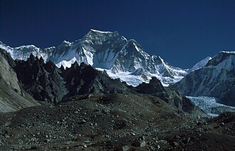 Mountain peaks
Gyachung Kang (Nepali: ग्याचुङ्काङ, Gyāchung Kāng; Chinese: 格重康峰; pinyin: Gézhòngkāng Fēng) is a mountain in the Mahalangur Himal section of the Himalayas, and is the highest peak between Cho Oyu (8,201 m) and Mount Everest (8,848 m).
Auf Wikipedia lesen Mountain peaks
Yala Peak is a mountain in the Langtang area in Nepal. It is considered a trekking peak by the Nepal Mountaineering Association, and is a relatively simple, non-technical climb.
Auf Wikipedia lesen Mountain peaks
Langtang Lirung is the highest peak of the Langtang Himal, which is a subrange of the Nepalese Himalayas, southwest of the Eight-thousander Shishapangma.
Auf Wikipedia lesen Fortifications
Rasuwa Fort or Rasuwa Gadhi (Nepali: रसुवागढी) is a historical fort ruin in the Rasuwa District of Nepal roughly at the border with Tibet, China.
Auf Wikipedia lesen Tower
TowerThe GhantaGhar (घन्टाघर) is the first public tower clock in Nepal, situated at the heart of the capital city of Kathmandu (near to Trichandra College). It lies in front of Rani Pokhari. It was built by Rana Prime Minister Bir Shumsher.
Auf Wikipedia lesenThe Jagdishpur Reservoir is a reservoir in Jahadi Village Development Committee, Kapilvastu District, Nepal. With a surface area of 225 ha (556 acres), it is the largest reservoir in the country and an important wetland site. It is situated at an altitude of 197 m (646 ft).
Auf Wikipedia lesenHardinge Park officially known as Shaheed Veer Kunwar Singh Azadi Park is a public park in the city of Patna built by British Raj in 1916. The park was initially named after Viceroy Charles Hardinge and was built in his honour as he was instrumental in the creation of Bihar as a separate province.
Auf Wikipedia lesenThe Jalan Museum (Hindi: जलान संग्रहालय), Quila house, is a private museum located in Patna, Bihar, India.
Auf Wikipedia lesenSri Sri Radha Banke Bihari Ji Mandir, generally known as the ISKCON Patna Temple, is the upcoming temple on Buddha Marg in Patna, Bihar, India.The construction of temple was started in 2007 and is expected to be completed by 2017 with an estimated budget of ₹51 crore (US$6.8 million).
Auf Wikipedia lesenGurdwara Bal Lila Maini Sangat in a narrow lane close to Takht Sri Harmandir Sahib marks the house where King Fateh Chand Maini lived.
Auf Wikipedia lesenSher Shah Suri Mosque, also known as Shershahi Mosque, is an example of the Afghan style of architecture. Sher Shah Suri built this mosque in 1540–1545 to commemorate his reign. It is sited in the south-west corner of Purab Darwaza near Dhawalpura.It was completed in 1545.
Auf Wikipedia lesenPava (now Padrauna) was a city in ancient India, at the time of Mahavira and Gautama Buddha. It was a city of the Mallas which the Buddha visited during his last journey, going there from Bhogagama and staying at Cunda's mango grove.
Auf Wikipedia lesenSingu Chuli (also known as Fluted Peak) is one of the trekking peaks in the Nepali Himalaya range. The peak is located just west of Ganggapurna in the Annapurna Himal. Singu Chuli is on a ridgeline originating at Tarke Kang going south. This ridge continues south of Singu Chuli to Tharpu Chuli.
Auf Wikipedia lesenPangpoche, also known as Panpoche I is a mountain in the Himalayas of Nepal. It has a summit elevation of 6,620 metres (21,720 ft) above sea level and is located approximately 15 kilometres (9.3 mi) northeast of the world's eighth-highest mountain, Manaslu (8,163 metres (26,781 ft)).
Auf Wikipedia lesenSitapaila is a village and former Village Development Committee that is now part of Nagarjun Municipality in Province No. 3 of central Nepal. At the time of the 1991 Nepal census it had a population of 5,156 and had 1,008 households in it.
Auf Wikipedia lesenThe sole sports Museum of Nepal, Nepal Olympic Museum, envisioned by its founder/president Chhitij Arun Shrestha, has been in existence since 1999 inside the premise of the National Sports Council, during the 8th South Asian Games Kathmandu.
Auf Wikipedia lesenThe Natural History Museum of Nepal is located near the World Heritage Site of Swayambhunath. The museum was established in 1975. Since then the museum has collected 50,000 specimens of Nepal’s flora and fauna.The Natural History Museum of Nepal has been publishing a journal annually since 1977.
Auf Wikipedia lesenSankha Park is a park near Chappal Karkhana, Kathmandu. The residents visit the park for picnicking, meeting and morning walk. The park is managed by Kathmandu Metropolitan City.
Auf Wikipedia lesenCentral Jail (Nepali: केन्द्रिय कारागार, Kendriya Karagar) is the largest prison facility of Nepal. It was established in 1971 BS. It is located near Newroad of central Kathmandu.
Auf Wikipedia lesenNepal, officially the Federal Democratic Republic of Nepal, is a landlocked country in South Asia. It is mainly situated in the Himalayas, but also includes parts of the Indo-Gangetic Plain. It borders the Tibet Autonomous Region of China to the north, and India to the south, east, and west, while it is narrowly separated from Bangladesh by the Siliguri Corridor, and from Bhutan by the Indian state of Sikkim.
Auf Wikipedia lesenBleiben Sie verbunden mit einem günstigen eSIM-Tarif — sofortige Aktivierung, keine Roaming-Gebühren.
eSIM-Tarife für Nepal ansehenDaten von OpenTripMap & OpenStreetMap