
Djibouti
Get instant mobile data with our premium eSIM plans. No physical SIM needed, just scan and go.
Discover Djibouti
Overview
Djibouti, officially the Republic of Djibouti, is a country in the Horn of Africa, bordered by Somalia to the south, Ethiopia to the southwest, Eritrea in the north, and the Red Sea and the Gulf of Aden to the east. The country has an area of 23,200 km2 (8,958 sq mi).
Read on WikipediaTravel Tips
Djibouti is in the Horn Peninsula on the Gulf of Aden. The country can be divided into three regions; the coastal plain and volcanic plateaus in the central and southern parts of the country and the mountain ranges in the north. Much of the country is wasteland with virtually no arable land.
Travel Guide on WikivoyageData from Wikipedia, Wikivoyage & REST Countries
Top Attractions in Djibouti
Must-visit places and landmarks
 Mountain peaks
Mountain of Ali Sabieh
The Ali Sabieh Mountain or The Mountain of the National Emblem (Somali: Buurta Cali Sabiix) is a landmark in the Ali Sabieh region of Djibouti. The national emblem of Djibouti is carved into the mountain. It overlooks Ali Sabieh and is a local landmark.
 Religious Site
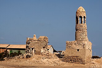
Masjid al-Qiblatayn
Masjid al-Qiblatayn (Arabic: مَـسْـجِـد الْـقِـبْـلَـتَـيْـن), also known as Labo-Qibla mosque is a mosque in Zeila, situated in the western Awdal region of Somaliland.The mosque, which translates to (Arabic: مَـسْـجِـد الْـقِـبْـلَـتَـيْـن…
 Campsites
Camp Lemonnier
Camp Lemonnier is a United States Naval Expeditionary Base, situated next to Djibouti–Ambouli International Airport in Djibouti City, and home to the Combined Joint Task Force – Horn of Africa (CJTF-HOA) of the U.S. Africa Command (USAFRICOM). It is the only permanent U.S.
 Religious Site
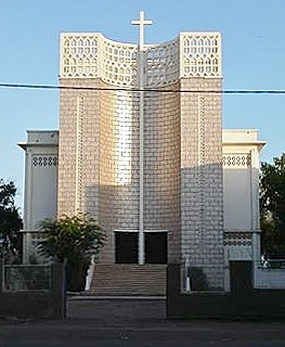
Our Lady of the Good Shepherd Cathedral, Djibouti
The Our Lady of the Good Shepherd Cathedral (French: Cathédrale Notre-Dame du Bon-Pasteur de Djibouti) or simply Cathedral of Djibouti, is a church built in the second half of the twentieth century.
 Religious Site
Hamoudi Mosque
Hamoudi Mosque (Arabic: مسجد الحمودي) is a mosque in Djibouti City, Djibouti.The mosque was built in 1901 by Haji Hamoudi.
 Religious Site
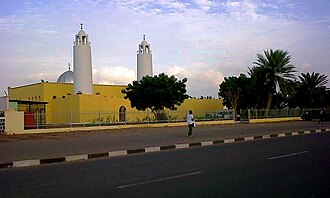
Salman Mosque
Amin Salman Mosque (Arabic: مسجد سلمان) is a mosque in Djibouti City, Djibouti.Salman Mosque has the capacity to accommodate up to 1,500 worshippers.Religion in Djibouti List of mosques in Africa Islam in Djibouti"Secretary Kerry At Salman Mosque in Djibouti". Retrieved 2015.
 Park
ParkDay Forest National Park
Day Forest National Park, also known as Forêt du Day National Park, is a national park in the Goda Mountains and Tadjourah Region of Djibouti.Along with Mount Mabla, the Forêt du Day National Park is one of Djibouti's two remnant areas of closed−protected forests.
 Other
OtherObock Region
The Obock Region (Afar: Rakaakay Obock, Arabic: إقليم أوبوخ, Somali: Gobolka Obokh) is a region in northern Djibouti. It has a land area of 4,700 square kilometres (1,800 sq mi), and had a population of 37,856 in 2009.
 Historic
Djibouti
Djibouti (also called Djibouti City and in many early English texts and on many early maps, Jibuti; Arabic: مدينة جيبوتي, French: Ville de Djibouti, Somali: Magaalada Jabuuti, Afar: Magaala Gabuuti) is the eponymous capital and largest city of Djibouti.
Agan
Lagarde Park
Lagarde Park is a public park in Djibouti City, the capital of Djibouti. It is situated near the city's center. The park sits at an altitude of about 11 m (36 ft), making it one of the settlement's highest points.
Ali Olo
The Ali Olo is a mountain located in the northeast of Ali Sabieh Region in Djibouti. With an average elevation of 286 metres (938 ft) above sea level, they are situated near the border with Somalia.
Attraction data from OpenTripMap & OpenStreetMap
Explore Nearby Destinations
Popular eSIM plans in the same region


Why Choose Our eSIM?
Instant Activation
Get your eSIM QR code instantly after purchase.
Stay Connected
High-speed data on local networks.
No Hidden Fees
Transparent pricing. No surprises.