 Landmark
Shaba National Reserve
Shaba National Reserve
Shaba National Reserve is a protected area in Isiolo County in northern Kenya to the east of the Samburu and Buffalo Springs national reserves.
Read on Wikipedia
Discover the most popular attractions, landmarks, and must-visit places in Kenya.
55 places to visit
LandmarkShaba National Reserve is a protected area in Isiolo County in northern Kenya to the east of the Samburu and Buffalo Springs national reserves.
Read on Wikipedia Mountain peaks
The Chyulu Hills is a mountain range in Makueni County, South Eastern Kenya. It forms a 100 kilometre long volcanic field in elongated NW-SE direction. Its highest peak is 2188 metres high.
Read on Wikipedia Mountain peaks
The Olkaria Area is a region located immediately to the south of Lake Naivasha in the Great Rift Valley of Kenya, Africa. It is geothermally active and is being used to generate clean electric power. The region has an estimated potential of 2,000 MW.
Read on Wikipedia Mountain peaks
Mount Longonot is a stratovolcano located southeast of Lake Naivasha in the Great Rift Valley of Kenya, Africa. It is thought to have last erupted in the 1860s. Its name is derived from the Maasai word Oloonong'ot, meaning "mountains of many spurs" or "steep ridges".
Read on Wikipedia Bridge
The Athi River Super Bridge is the longest bridge on the Mombasa–Nairobi Standard Gauge Railway (SGR). It was built to carry a single-track railway line over the Athi River as it approaches the Kenyan capital city of Nairobi.
Read on Wikipedia Urban
UrbanNairobi National Park is a national park in Kenya that was established in 1946 about 7 km (4.3 mi) south of Nairobi. It is fenced on three sides, whereas the open southern boundary allows migrating wildlife to move between the park and the adjacent Kitengela plains.
Read on Wikipedia Religious Site
The Cathedral Basilica of the Holy Family is a Catholic Church Cathedral and Basilica dedicated to the Holy Family located around City Square in Nairobi, the Capital City of the Republic of Kenya. The Basilica is the seat of the Archdiocese of Nairobi.
Read on Wikipedia Mountain peaks
Mount Kilimanjaro () is a dormant volcano in Tanzania. It has three volcanic cones: Kibo, Mawenzi, and Shira. It is the highest mountain in Africa and the highest single free-standing mountain in the world: 5,895 metres (19,341 ft) above sea level and about 4,900 metres (16,100 ft) above its plateau…
Read on Wikipedia Mountain peaks
Gelai Volcano also known as Mount Gelai stands at 2,942 metres (9,652 ft) tall and is located in Ngorongoro District, Arusha Region, Tanzania in the Crater Highlands. It is at the southeastern edge of Lake Natron in the East African Rift.
Read on Wikipedia Landmark
 Water
WaterNyahururu Falls is a 74 metres (243 ft) waterfall on the Ewaso Ng'iro river in Central Rift Valley Kenya, a few kilometres from Lake Ol Bolossat, which drains from the Aberdare Range. It is situated 3 kilometres (2 mi) from the town of Nyahururu, at 2,360 metres (7,740 ft) elevation.
Read on Wikipedia Mountain peaks
Menengai Crater is a massive shield volcano with one of the biggest calderas in the world, in the Great Rift Valley, Kenya. It is the largest volcano caldera in Kenya and the second largest volcano caldera in Africa. Volcanic formed rich loam soils enrich the adjacent farmland arounds its flanks.
Read on Wikipedia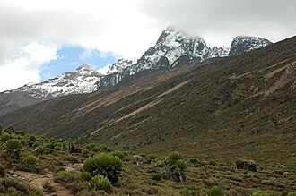 Geological formations
Mount Kenya is the highest mountain in Kenya and the second-highest in Africa, after Kilimanjaro. The highest peaks of the mountain are Batian (5,199 metres or 17,057 feet), Nelion (5,188 m or 17,021 ft) and Point Lenana (4,985 m or 16,355 ft).
Read on Wikipedia Cultural
The Karen Blixen Museum, located 10 km outside of Nairobi, Kenya, "at the foot of the Ngong Hills", is the former African home of Danish author Karen Blixen, famous for her 1937 book Out of Africa which chronicles life at the estate.
Read on Wikipedia Urban
UrbanThe Giraffe Centre is located in Lang'ata, approximately 20 kilometres (12 mi) from the centre of Nairobi, Kenya. It was established in order to protect engangered species of giraffe found only in the grasslands of East Africa.
Read on Wikipedia Cultural
Bomas of Kenya is a tourist village in Langata, Nairobi. Bomas (homesteads) displays traditional villages belonging to the several Kenyan tribes. Bomas of Kenya is home to one of largest auditorium in Africa.
Read on Wikipedia Urban
UrbanUhuru Gardens Memorial Park is a commemorative park in Nairobi, Kenya that celebrates independence from the British Empire in 12 December 1963. The word "uhuru" is Swahili for "freedom". It contains three points of significance:
Read on Wikipedia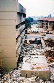 Historic
The 1998 United States embassy bombings were attacks that occurred on August 7, 1998. More than 200 people were killed in nearly simultaneous truck bomb explosions in two East African cities, one at the United States Embassy in Dar es Salaam, Tanzania, the other at the United States Embassy in Nairo…
Read on Wikipedia Cultural
Strathmore University is a chartered university based in Nairobi, Kenya.Strathmore College was started in 1961, as the first multi-racial, multi-religious advanced-level sixth form college offering science and arts subjects, by a group of professionals who formed a charitable educational trust (now…
Read on Wikipedia Cultural
Westgate Shopping Mall (also known as Westgate) is an upscale shopping mall located in the Westlands division of Nairobi, Kenya. It was first opened in 2007. A 2013 terrorist attack on the mall resulted in the death of at least 67 people, including four attackers, with 175 non-fatal injuries.
Read on Wikipedia Skyscrapers
UAP Old Mutual Tower is a 33-storey office complex in the Upper Hill neighborhood of Nairobi, the capital and largest city in Kenya.
Read on Wikipedia Religious Site
Jamia Mosque is a mosque located on Banda Street, Nairobi, Kenya in the Central Business District. The mosque is one of Kenya's most prominent religious structures, and the most important mosque in the country. It was founded and first built by Syed Maulana Abdullah Shah between 1902 and 1906.
Read on Wikipedia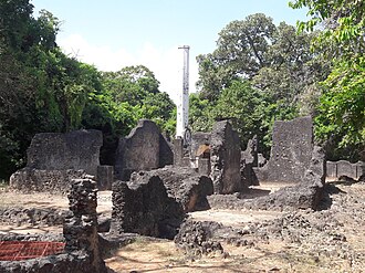 Other
OtherThe Mnarani ruins are the remains of two mosques near Mnarani in Kilifi County, Kenya. Dating from the 15th century, the mosques are located on a bluff overlooking Kilifi Creek from the southern side.
Read on Wikipedia Historic
The ruins of Gedi are a historical and archaeological site near the Indian Ocean coast of eastern Kenya. The site is adjacent to the town of Gedi (also known as Gede) in the Kilifi District and within the Arabuko-Sokoke Forest.Gedi is one of many medieval Swahili coastal settlements that stretch fro…
Read on WikipediaHistoricGede (also known as Gedi) is a village on the Indian Ocean coast of Kenya, lying in Kilifi County, south of Malindi and north of Watamu. The Ruins of Gedi are located there.
Read on Wikipedia Urban
UrbanTsavo East National Park is one of the oldest and largest parks in Kenya at 13,747 square kilometres. Situated in a semi-arid area previously known as the Taru Desert it opened in April 1948, and is located near the town of Voi in the Taita-Taveta County of the former Coast Province.
Read on Wikipedia Water
WaterLake Nakuru is one of the Rift Valley lakes at an elevation of 1,754 m (5,755 ft) above sea level. It lies to the south of Nakuru, in the rift valley of Kenya and is protected by Lake Nakuru National Park.The lake's abundance of algae used to attract a vast quantity of flamingos that famously lined…
Read on Wikipedia Other
OtherLocated near Nanyuki, about 199.2 km North East of Nairobi in Kenya's Central Province, the Mau Mau Cave was used as a hide-out by Kenyan Freedom Fighters during the Mau Mau Uprising of 1952 to 1960. It is located approximately 18 km south of the equator inside the thick Mount Kenya National Park.
Read on Wikipedia Historic
The graves of Lieutenant-General The 1st Baron Baden-Powell and his wife, Olave, Baroness Baden-Powell, G.B.E., are in Nyeri, Nyeri County, Kenya, near Mount Kenya. Lord Baden-Powell died on 8 January 1941, and is buried in St. Peter's Cemetery in the Wajee Nature Park.
Read on Wikipedia Landmark
Credner Glacier is on Mount Kilimanjaro in Tanzania, on the northwest slope of the peak and is a remnant of an icecap which once crowned the top of Mount Kilimanjaro. The glacier is situated at an elevation of between 5,800 and 5,500 metres (19,000 and 18,000 ft).
Read on WikipediaLandmarkGreat Penck Glacier was on Mount Kilimanjaro in Tanzania, on the west slope of the peak. Extending from the Northern Ice Field, the glacier once flowed 2.4 kilometres (1.5 mi), to an elevation of 4,750 metres (15,580 ft).
Read on Wikipedia Mountain peaks
Ol Doinyo Lengai (Oldoinyo Lengai), "Mountain of God" in the Maasai language, is an active volcano located in the Gregory Rift, south of Lake Natron within the Arusha Region of Tanzania, Africa. Part of the volcanic system of the East African Rift, it uniquely produces natrocarbonatite lava.
Read on Wikipedia Urban
UrbanThe Serengeti National Park is a large national park in northern Tanzania that stretches over 14,763 km2 (5,700 sq mi). It is located entirely in eastern Mara Region and north east portion of Simiyu Region and contains over 15,000,000 hectares (37,000,000 acres) of virgin savanna.The Serengeti is we…
Read on Wikipedia Historic
The Kondoa Irangi Rock Paintings are a series of ancient paintings on rockshelter walls in central Tanzania. The Kondoa region was declared a UNESCO World Heritage site in 2006 because of its impressive collection of rock art.
Read on Wikipedia Nature
The Ngorongoro Conservation Area (UK: , US: ) is a protected area and a UNESCO World Heritage Site located in Ngorongoro Distric, 180 km (110 mi) west of Arusha City in Arusha Region, within the Crater Highlands geological area of northern Tanzania.
Read on Wikipedia Other
OtherThe Aberdare Range (formerly the Sattima Range, Kikuyu: Nyandarua) is a 160 km (100 mile) long mountain range of upland, north of Kenya's capital Nairobi with an average elevation of 3,500 metres (11,480 ft). It straddles across the counties of Nyandarua, Nyeri, Muranga, Kiambu and Laikipia.
Read on Wikipedia Urban
UrbanHell's Gate National Park lies south of Lake Naivasha in Kenya, north west of Nairobi. Hell's Gate National Park is named after a narrow break in the cliffs, once a tributary of a prehistoric lake that fed early humans in the Rift Valley. It was established in 1984.
Read on Wikipedia Water
WaterLake Naivasha is a freshwater lake in Kenya, outside the town of Naivasha in Nakuru County, which lies north west of Nairobi. It is part of the Great Rift Valley. The name derives from the local Maasai name Nai'posha, meaning "rough water" because of the sudden storms which can arise.
Read on Wikipedia Water
WaterLake Elmenteita is a soda lake, in the Great Rift Valley, about 120 km northwest of Nairobi, Kenya.Elmenteita is derived from the Maasai word muteita, meaning "dust place", a reference to the dryness and dustiness of the area, especially between January and March.
Read on Wikipedia Landmark
Kakamega Forest is a tropical rainforest situated in the Kakamega and Nandi County of Kenya, northwest of the capital Nairobi, and near to the border with Uganda.
Read on Wikipedia Settlements
Thimlich Ohinga is a complex of stone-built ruins in Migori county, Nyanza Kenya, in East Africa. It is the largest one of 138 sites containing 521 stone structures that were built around the Lake Victoria region in Kenya. These sites are highly clustered.
Read on Wikipedia Other
OtherThe olive baboon (Papio anubis), also called the Anubis baboon, is a member of the family Cercopithecidae (Old World monkeys). The species is the most wide-ranging of all baboons, being found in 25 countries throughout Africa, extending from Mali eastward to Ethiopia and Tanzania.
Read on Wikipedia Other
OtherEuphaedra rex is a butterfly in the family Nymphalidae. It is found in Uganda and Kenya.
Read on WikipediaLandmarkArrow Glacier is located near the summit of Mount Kilimanjaro in Tanzania, on the west slope of the peak and is a small remnant of an icecap which once crowned the summit of Mount Kilimanjaro. The glacier is situated at an elevation of between 5,470 and 5,300 metres (17,950 and 17,390 ft).
Read on WikipediaLandmarkThe Northern Ice Field is near the summit of Mount Kilimanjaro in Tanzania, on the west slope of the peak. The Northern Ice Field and Eastern Ice Fields were connected to the Southern Ice Field and formed part of a continuous body of glacial ice atop Mount Kilimanjaro when first scientifically exami…
Read on Wikipedia Historic
Olorgesailie is a geological formation in East Africa containing a group of Lower Paleolithic archaeological sites. It is on the floor of the Eastern Rift Valley in southern Kenya, 67 kilometres (42 mi) southwest of Nairobi along the road to Lake Magadi.
Read on WikipediaLake Bisina, also known as Lake Salisbury, is a freshwater lake in eastern Uganda. It is a satellite lake of Lake Kyoga, which it drains into and the two are to some extend directly connected by papyrus swamps.
Read on WikipediaLake Opeta is a lake with an extensive wetland system in Uganda.The wetland lies south of the Pian Upe Wildlife Reserve and serves as a dry-season refuge for both wildlife from the park and domestic cattle of the surrounding Karamajong and Pokot people.Lake Opeta is primarily fed by rainfall on Moun…
Read on WikipediaThe Tana River Delta Ramsar Site is a wetland on the Tana River protected under the Ramsar Convention located in the Coast Province of Kenya.
Read on WikipediaThe Kapenguria Museum is a museum located in Kapenguria, Kenya. The museum is located inside the prison where prominent leaders of the Kenyan independence movement (the Kapenguria Six: Jomo Kenyatta, Kungu Karumba, Fred Kubai, Paul Ngei, Bildad Kaggia and Ramogi Achieng Oneko) were held and put on t…
Read on WikipediaThe Roman Catholic Diocese of Bunda (Latin: Dioecesis Bundana) is a diocese located in Bunda Town in the Ecclesiastical province of Mwanza in Tanzania.November 27, 2010: Established as Diocese of Bunda from the Archdiocese of Mwanza and the Diocese of Musoma.The diocese comprises the districts of Bu…
Read on WikipediaThe Northern Acacia-Commiphora bushlands and thickets are a tropical grasslands, savannas, and shrublands ecoregion in eastern Africa.
Read on WikipediaThe Mara Triangle is the southwestern part of the Maasai Mara National Reserve, Kenya, and is managed by the not-for-profit organisation The Mara Conservancy on behalf of Trans-Mara County Council.Divided from the rest of the Maasai Mara National Reserve by the Mara River, the Mara Triangle is less…
Read on WikipediaThe Pinnacle, also Pinnacle Towers, is a building on hold in Nairobi, the capital and largest city of Kenya. When completed, the skyscraper is expected to become the second tallest building in Africa after Egypt's Iconic Tower, and the third tallest building in the Southern Hemisphere, at 70 stories…
Read on WikipediaUhuru Park is a 12.9 hectare recreational park adjacent to the central business district of Nairobi, Kenya. It was opened to the general public by the late Mzee Jomo Kenyatta on 23 May 1969.
Read on WikipediaKenya, officially the Republic of Kenya, is a country located in East Africa. With an estimated population of more than 54.2 million as of mid-2026, it is the 27th-most populous country in the world and the seventh-most populous in Africa. Kenya's capital and largest city is Nairobi. The second-largest and oldest city is Mombasa, a port city located on Mombasa Island. Other major cities within the country include Kisumu, Nakuru and Eldoret.
Read on WikipediaStay connected with an affordable eSIM plan — instant activation, no roaming fees.
View eSIM Plans for KenyaAttraction data from OpenTripMap & OpenStreetMap