
Cotacachi Cayapas Ecological Reserve
Cotacachi Cayapas Reserve contains 752,235 acres (3,044 km2) of land and is located in the Imbabura and Esmeraldas provinces of Ecuador 87 miles (140 km) from Quito.
Auf Wikipedia lesenEntdecken Sie die beliebtesten Attraktionen, Wahrzeichen und Sehenswürdigkeiten in Ecuador.
52 Orte zu besuchen
Cotacachi Cayapas Reserve contains 752,235 acres (3,044 km2) of land and is located in the Imbabura and Esmeraldas provinces of Ecuador 87 miles (140 km) from Quito.
Auf Wikipedia lesenThe Illinizas are a pair of volcanic mountains that are located in the north of Latacunga, Cotopaxi, Ecuador. They are located in the Illinizas Ecological Reserve (Spanish: Reserva Ecológica Los Illinizas). These twin mountains are separated by a saddle that is about a kilometer long.
Auf Wikipedia lesenCotopaxi is an active stratovolcano in the Andes Mountains, located in Latacunga city of Cotopaxi Province, about 50 km (31 mi) south of Quito, and 31 km (19 mi) northeast of the city of Latacunga, Ecuador, in South America.
Auf Wikipedia lesenAntisana is a stratovolcano of the northern Andes, in Ecuador. It is the fourth highest volcano in Ecuador, at 5,753 metres (18,875 ft), and is located 50 kilometres (31 mi) SE of the capital city of Quito.Antisana presents one of the most challenging technical climbs in the Ecuadorian Andes.
Auf Wikipedia lesenCotopaxi National Park (Spanish: Parque Nacional Cotopaxi) is a protected area in Ecuador situated in the Cotopaxi Province, Napo Province and Pichincha Province, roughly 50 km (31 mi) south of Quito.
Auf Wikipedia lesenMojanda is an inactive stratovolcano of the Eastern Cordillera of the Andes in northern Ecuador. A summit caldera, which was produced by an explosive Plinian Eruption that marked the end of Mojanda activity 200,000 years ago, is occupied by three crater lakes: Karikucha (the largest), Yanakucha, and…
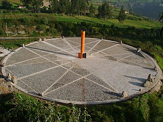
Auf Wikipedia lesenThe Quitsato Sundial is a cultural-tourist place located at La Mitad Del Mundo, near to Cayambe, 47 km north of Quito, Ecuador. It was built in 2006 and inaugurated in 2007 as an independent, non-profit project in a 24,756 ft² (2300 m²) area.
Auf Wikipedia lesenRumiñahui ( roo-mee-NYAH-wee, Kichwa rumi stone, rock, ñawi eye, face, "stone eye", "stone face", "rock eye" or "rock face", Hispanicized spelling Rumiñahui, Spanish pronunciation: [rumiˈɲawi]) is a dormant, heavily eroded stratovolcano 4,721 metres (15,489 ft) above sea level.
Auf Wikipedia lesenThe Ciudad Mitad del Mundo (Spanish: [La mitad del mundo], Middle of the World City) is a tract of land owned by the prefecture of the province of Pichincha, Ecuador. It is located at San Antonio parish of the canton of Quito, 26 km (16 mi) north of the center of Quito.
Auf Wikipedia lesenAtacazo is a volcano of the Western Cordillera located 25 kilometers southwest of Quito, Ecuador. Atacazo is a stratovolcano formed by the action of a Late-Pleistocene to Holocene caldera.
Auf Wikipedia lesenPichincha is a stratovolcano in Ecuador. The capital Quito wraps around its eastern slopes.The two highest peaks of the mountain are Wawa Pichincha (Kichwa wawa child, baby / small, Spanish spelling Guagua Pichincha) (4,784 metres (15,696 ft)) and Ruku Pichincha (Kichwa ruku old person, Spanish Rucu…
Auf Wikipedia lesenThe painter Oswaldo Guayasamín's La Capilla del Hombre ("The Chapel of Man") occupies a site in Bellavista overlooking the city of Quito, Ecuador. The Capilla is a purpose-built art museum dedicated to the peoples of Latin America.
Auf Wikipedia lesenParque La Carolina is a 165.5-acre (670,000 m²) park in the centre of the Quito central business district, bordered by the avenues Río Amazonas, de los Shyris, Naciones Unidas, Eloy Alfaro, and de la República.This park started from the expropriation of the farm La Carolina in 1939.
Auf Wikipedia lesenQuito Botanical Garden (Spanish: Jardín Botánico de Quito) is a park, botanical garden, arboretum and greenhouse s of 18,600 square meters that it is planned to increase, it houses species of plants of the country (Ecuador is among the 17 richest countries in the world in native botanical species…
Auf Wikipedia lesenThe TelefériQo (from teleférico and Quito), or TelefériQo Cruz Loma, is a gondola lift in Quito, Ecuador, running from the edge of the city centre up the east side of Pichincha Volcano to lookout Cruz Loma.
Auf Wikipedia lesenLa Casa de la Cultura Ecuatoriana (The House of Ecuadorian Culture) is a cultural organization founded by Benjamín Carrión on August 9, 1944, during the presidency of Dr Jose Maria Velasco Ibarra.
Auf Wikipedia lesenThe Cathedral of the Immaculate Conception (Spanish: Catedral de la Inmaculada Concepción), commonly referred to as the New Cathedral of Cuenca (Spanish: Nueva Catedral de Cuenca), is the cathedral church in Cuenca, Ecuador. It is situated in front of Parque Calderon.
Auf Wikipedia lesenSanta Ana de los Cuatro Ríos de Cuenca, commonly referred as Cuenca (Quechua: Tumipampa) is the capital and largest city of the Azuay Province of Ecuador.
Auf Wikipedia lesenMachalilla National Park (Spanish: Parque Nacional Machalilla) is a preserve in the Ecuadorian Manabí Province near Puerto López and the rural parish of Machalilla, a small fishing village in the vicinity of the park.Established in 1979, Machalilla National Park near Puerto Lopéz rests along the…
Auf Wikipedia lesen
NatureReserva Geobotánica Pululahua (Pululahua Geobotanical Reserve) (Cloud of Water Geobontanical Reserve) is a protected area around Pululahua Volcano in the north of Quito Canton, Pichincha Province, Ecuador. It is 17 km north of Quito, in the northwestern part of the Pomasqui Valley.
Auf Wikipedia lesenPululahua is a dormant volcano in the north of Quito Canton, Pichincha Province, Ecuador. The volcano is in the Western Cordillera of the northern Ecuadorian Andes, approximately west-southwest of Mojanda and north of Casitahua volcanoes.
Auf Wikipedia lesenPasochoa (4,200 metres) is an extinct volcano located in the Guayllabamba river basin in the Ecuadorian Andes. The current mountain form is a collapsed crater with a semicircular shape.
Auf Wikipedia lesenMonte Catequilla (also Kati-Killa) is an archaeological site in the Pomasqui Valley of Ecuador. Located in the Parish of San Antonio of Quito Canton in Pichincha Province, it has an elevation of 2,638 metres (8,655 ft) and is located on a mountaintop about 300 metres (980 ft) above valleys on either…
Auf Wikipedia lesenFrancisco de Orellana Bejarano Pizarro y Torres de Altamirano (Spanish pronunciation: [fɾanˈθisko ðe oɾeˈʝana]; 1511 – November 1546) was a Spanish explorer and conquistador.
Auf Wikipedia lesenThe Virgin of El Panecillo (in Spanish: Virgen de El Panecillo), also known as the Virgin of Quito from the sculpture of the same name, is a monument in Quito, Ecuador.
Auf Wikipedia lesenCasa del Alabado is a Precolumbian Art Museum in Quito, Ecuador. The museum is located in a colonial house built in the 17th century during the Spanish Colony. It houses a collection of over 5,000 archaeological pieces, 500 of which are on permanent display.
Auf Wikipedia lesenThe Quito Astronomical Observatory (Spanish: Observatorio Astronómico de Quito – OAQ) is a research institute of EPN, the National Polytechnic School in Quito, Ecuador.
Auf Wikipedia lesenParque La Alameda is a park in the Old Centre part of Quito, Ecuador. It is located southeast of Parque Julio Montevelle and east of Parque de La Basílica. It contains a notable equestrian monument of Simon Bolivar and an astronomical observatory in the centre.
Auf Wikipedia lesenZaruma, officially Villa Real de San Antonio del Cerro de Oro de Zaruma is a town in the south of Ecuador, El Oro Province.
Auf Wikipedia lesenSangay National Park (Spanish: Parque Nacional Sangay) is a national park located in the Morona Santiago, Chimborazo and Tungurahua provinces of Ecuador. The park contains two active volcanoes (Tungurahua and Sangay), one extinct volcano El Altar (Kapak Urku).
Auf Wikipedia lesenThe National Shrine Basilica of Our Lady of Las Lajas (Spanish: Basílica Santuario Nacional de Nuestra Señora de las Lajas), commonly called Las Lajas Shrine (Santuario de Las Lajas), is a basilica church located in the southern Colombian Department of Nariño, in the municipality of Ipiales, and…
Auf Wikipedia lesenThe Church and Convent of St. Francis (Spanish: Iglesia y Convento de San Francisco), commonly known as el San Francisco, is a 16th-century Roman Catholic complex in Quito, Ecuador. It fronts onto its namesake Plaza de San Francisco.
Auf Wikipedia lesenThe City Museum (Museo de la Ciudad) is a museum in the colonial center of Quito, Ecuador. It is located on Garcia Moreno Street, between Morales and Rocafuerte.The museum was founded in 1998 and occupies the buildings of what once was the San Juan de Dios Hospital.
Auf Wikipedia lesenCarondelet Palace (Spanish: Palacio de Carondelet) is the seat of government of the Republic of Ecuador, located in Quito.
Auf Wikipedia lesenSucre House (Spanish: Museo Casa de Sucre) is a museum in the historic center of Quito, Ecuador. It was established in 1977 by the Ministry of Defence.
Auf Wikipedia lesenThe Metropolitan Cathedral of Quito (Spanish: Catedral Metropolitana de Quito), known simply as la Catedral, is the Catholic cathedral in Quito, Ecuador.
Auf Wikipedia lesenParque El Ejido is a park located along Avenue Patria in the Old Centre part of Quito, Ecuador. It is the third-largest park in the city. Estadio El Ejido is located nearby. The park hosts exhibitions on the weekend.
Auf Wikipedia lesenThe Basilica of the National Vow (Spanish: Basílica del Voto Nacional) is a Roman Catholic church located in the historic center of Quito, Ecuador. It is the largest neo-Gothic basilica in the Americas.
Auf Wikipedia lesenOperación Fénix (English: Operation Phoenix), was an attack by the Colombian military against a camp of the guerrilla group the Revolutionary Armed Forces of Colombia (FARC) 1.8 kilometers (1.1 mi) over the border in Sucumbíos Province, Ecuador on March 1, 2008.
Auf Wikipedia lesenAntisana Ecological Reserve (Spanish: Reserva Ecológica Antisana) is a protected area in Ecuador situated in the Napo Province, Quijos Canton and Archidona Canton.Rare animals and plants found in or near the reserve include:
Auf Wikipedia lesenTeatro Bolívar is a theatre in Quito, Ecuador. It was established on 15 April 1933, with a capacity of 2400 spectators. It hosted many notable events, including the Miss Ecuador 1996 contest.
Auf Wikipedia lesenThe Iglesia de San Agustín (Church of Saint Augustine) is a historic 16th century structure located in Old Town Quito, Ecuador.
Auf Wikipedia lesenThe Gulf of Guayaquil–Tumbes mangroves (NT1413) are an ecoregion located in the Gulf of Guayaquil in South America, in northern Peru and southern Ecuador.
Auf Wikipedia lesenSantay Island (Spanish Isla Santay) is a 2200 ha. island located in Guayas, Ecuador. It is part of the Durán Canton. It is surrounded by the Guayas River and populated by 47 families living there since the 1950s and before.
Auf Wikipedia lesenThe Ferrocarriles del Ecuador Empresa Publica (FE EP) (Ecuadorian Railways Company) is the national railway of Ecuador. The railway system was devised to connect the Pacific coast with the Andean highlands.
Auf Wikipedia lesenSanta Isabel Canton is a canton of Ecuador, located in the Azuay Province. Its capital is the town of Santa Isabel. Its population at the 2001 census was 18,015.Ethnic groups as of the Ecuadorian census of 2010:Mestizo 92.5% White 4.4% Afro-Ecuadorian 2.2% Indigenous 0.5% Montubio 0.2% Other 0.2%
Auf Wikipedia lesenThe Ferrocarriles del Ecuador Empresa Publica (FE EP) (Ecuadorian Railways Company) is the national railway of Ecuador. The railway system was devised to connect the Pacific coast with the Andean highlands.
Auf Wikipedia lesenMedicinal Plants Orito Ingi-Ande Flora Sanctuary (Spanish: Santuario de Flora Plantas Medicinales Orito Ingi-Ande) is the newest protected area in Colombia.
Auf Wikipedia lesenEl Encano is a settlement in Pasto Municipality, Nariño Department in Colombia.El Encano has a subtropical highland climate (Cfb).
Auf Wikipedia lesenThe San Rafael Falls (Spanish: La Cascada San Rafael) were, until 2 February 2020, the tallest falls in Ecuador. The 130-metre (430 ft) falls were located on the Coca River in Cayambe Coca Ecological Reserve until a collapse of the river bed upstream of the falls diverted the river underneath the ba…
Auf Wikipedia lesenChacana is a large 32-km long - 18-24 km wide caldera that has erupted in historical times. It forms one of the largest rhyolite centers in the Northern Andes with major eruptions over the past 240,000, 180,00, and 160,000 years ago and has had andesitic-rhyolitic volcanism.
Auf Wikipedia lesenEcuador, officially the Republic of Ecuador, is a country in northwestern South America, bordered by Colombia on the north, Peru on the east and south, and the Pacific Ocean on the west. It also includes the Galápagos Province which contains the Galápagos Islands in the Pacific, about 1,000 kilometers west of the mainland. The country's capital is Quito, and the largest city is Guayaquil.
Auf Wikipedia lesenBleiben Sie verbunden mit einem günstigen eSIM-Tarif — sofortige Aktivierung, keine Roaming-Gebühren.
eSIM-Tarife für Ecuador ansehenDaten von OpenTripMap & OpenStreetMap